Contents
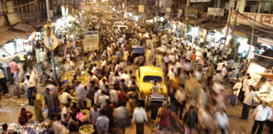
west bengal census 2011
- According to the Census 2011, West Bengal is the 4th most populated state in India.
- West Bengal is the 9th most populated state in the world.
West Bengal census 2011
West Bengal population density
West Bengal Census 2011
| 2011 | 2001 | |
|---|---|---|
| Population | 9.13 Cr. | 8.02 Cr. |
| Population Growth | 13.84% | 17.84% |
| Percentage of Indian Population | 7.54% | 7.79% |
| Area (sq.km) | 88,752 | |
| Area | 88,752 | 14th in India |
| Percentage of India's Area | 2.7% | |
| Density/sq.km | 1,028 | 903 |
| Sex Ratio | 950 | 934 |
| Child Sex Ratio | 956 | 960 |
| Literacy | 76.26% | 68.64% |
| Male Literacy | 81.69% | 77.02% |
| Female Literacy | 70.54% | 59.61% |
| GDP | ₹12.54 lakh cr. (2019–20) | |
| GDP Per Capita | ₹ 1.15 lakh (2019–20) | |
| HDI Rank in India | 28th (0.641) | |
| Life expectancy at birth | 70.2 years |
West Bengal population density
Sponsored

West Bengal census 2011
Rural & Urban Census Data
| Rural | Urban | |
|---|---|---|
| Population | 68.13% | 31.87% |
| Population Growth | 7.68 % | 29.72 % |
| Sex Ratio | 953 | 944 |
| Literacy | 72.13 % | 84.78 % |
| Male Literacy | 78.44 % | 88.37 % |
| Female Literacy | 61.98 % | 76.01 % |
West Bengal population density
District Wise Ranking
| 1st | 2nd | 3rd | |
|---|---|---|---|
| Population | |||
| Highest | North 24 Pgs | South 24 Pgs | Bardhaman |
| Lowest | South Dinajpur | Darjeeling | Cooch Behar |
| Population Growth | |||
| Highest | North Dinajpur | Malda | Murshidabad |
| Lowest | Kolkata | Hooghly | South Dinajpur |
| Population Density | |||
| Highest | Kolkata | Howrah | North 24 Pgs |
| Lowest | Purulia | Bankura | Darjeeling |
| Gross Domestic Product | |||
| Highest | North 24 Pgs | Bardhaman | Kolkata |
| Lowest | South Dinajpur | North Dinajpur | Cooch Behar |
| GDP Per Capita | |||
| Highest | Kolkata | Darjeeling | Purba Medinipur |
| Lowest | North Dinajpur | South Dinajpur | Purulia |
| Sex Ratio | |||
| Highest | Darjeeling | West Midnapore | Hooghly |
| Lowest | Kolkata | Howrah | East Midnapore |
| Child Sex Ratio | |||
| Highest | Howrah | Mursidabad | Nadia |
| Lowest | Kolkata | Paschim Medinipur | Darjeeling & Bankura |
| Literacy | |||
| Highest | East Midnapore | Kolkata | North 24 Pgs |
| Lowest | North Dinajpur | Malda | Purulia |
| Female Literacy | |||
| Highest | Kolkata | East Midnapore | North 24 Pgs |
| Lowest | Purulia | North Dinajpur | Malda |
| SC population | |||
| Highest | Cochbihar | Jalpaiguri | South 24 Pgs |
| ST population | |||
| Highest | Jalpaiguri | Purulia | South Dinajpur |
| HDI | |||
| Highest | Kolkata | Howrah | North 24 Pgs |
| Lowest | Malda | Purulia | Murshidabad |
West Bengal population density
West Bengal census 2011
Local Government Wise Ranking
| 1st | 2nd | 3rd | |
|---|---|---|---|
| Municipal Corporation | |||
| Most Populated | Kolkata | Howrah | Durgapur |
| Municipality | |||
| Most Populated | Maheshtala | Rajpur Sonarpur | South Dum Dum |
| Metropolitan Region | |||
| Most Populated | Kolkata | Asansol | Siliguri |
West Bengal census 2011
Sponsored
Data Source
https://www.census2011.co.in/census/state/west+bengal.html