Contents
>>>>>>
Physiographic Divisions of India
- Northern Mountains – 10.6 %
- Peninsular Plateau – 27.7 %
- Indo-Gangetic Plain – 43% total plain
- Coastal Plains
- Islands
- Desert – 4.5%
>>>>>>>
>>>>>>>
The Himalayan Mountains
Origin & Development of the Himalayas
- India is situated entirely on the Indian Plate, a major tectonic plate that was formed when it split off from the ancient continent Gondwanaland.
- Indo-Australian plate is subdivided into the Indian and Australian plates.
- About 90 million years ago, during the late Cretaceous Period, the Indian Plate began moving north at about 15 cm/year.
- About 50 to 55 million years ago, in the Eocene Epoch of the Cenozoic Era, the plate collided with Asia after covering a distance of 2,000 to 3,000 km.
- The collision with the Eurasian Plate along the modern border between India and Nepal formed the orogenic belt that created the Tibetan Plateau and the Himalayan mountains.
Himalayan Mountains are still Rising
- Himalaya is a young fold mountain range and it still raising.
- Fossil formation found in Shivalik hills
- Similar fossils have also been found in the Tibet Plateau.
- In the past, Tibetan plateau and Shivalik hills shared a common location, similar level and thus similar vegetation, life etc.
- Then Tibetan plateau got uplifted.
- Desiccation of lakes of Tibet
- In the Tibet plateau, we find deposits which generally found in lakes.
- It indicates that lakes once existed in Tibet but because of upliftment the water got discharged and deposits remained.
- Frequent Earthquakes
- Youthful nature of rivers
- High erosion, v-shaped valleys
>>>>>>>

>>>>>>>
South to North Divisions of the Himalayas
- The Himalayas consist of a series of parallel mountain ranges
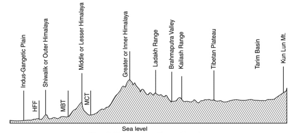
- Outer Himalayas (or Shiwalik)
- Lesser Himalayas (or Himachal)
- Greater Himalayan range, which includes:
- Great Himalayas (Himadri)
- Trans-Himalayan range
Outer Himalayas or Shiwalik
- Shiwalik Located in between the Great Plains and Lesser Himalayas.
- Altitude varies from 600 to 1500 meters.
- Runs for a distance of 2,400 km from the Potwar Plateau to the Brahmaputra valley.
- The southern slopes are steep while the northern slopes are gentle.
- The width of the Shiwaliks varies from 50 km in Himachal Pradesh to less than 15 km in Arunachal Pradesh.
- They are almost unbroken chain of low hills except for a gap of 80-90 km, occupied by the valley of the Tista River and Raidak River.
- Shiwalik is known by different names in different areas
- Jammu – Jammu Hills
- Dafla, Miri, Abor, Mishmi Hills – Arunachal Pradesh
- Dhang, Dundwa – Uttarakhand
- Churia Ghat – Nepal
Formation of Duns (Duras)
- Shiwalik Hills were formed by the accumulation of conglomerates (sand, stone, silt, gravel, debris etc.).
- These conglomerates, in the initial stages of deposition, obstructed the courses of the rivers draining from the higher reaches of the Himalayan mountains and formed temporary lakes.
- With passage of time, these temporary lakes accumulated more and more conglomerates.
- When the rivers were able to cut their courses through the lakes filled with conglomerate deposits, the lakes were drained away leaving behind plains called ‘duns’ or ‘doons’ in the west and ‘duars’ in the east.
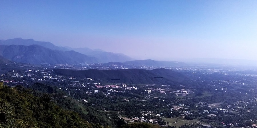
- Dehra Dun in Uttarakhand is the best example.
- Potli Kothri, Chumbi, Kyarda, Chaukhamba, Udhampur and Kotli are other important duns.
Middle or Lesser Himalayas or Himachal
- In between the Shiwaliks in the south and the Greater Himalayas in the north.
- Lesser Himalayas runs almost parallel to both the ranges.
- It is 60-80 km wide and about 2400 km in length.
- Elevations of lesser Himalayas vary from 3,500 to 4,500 m.
- Many peaks are more than 5,050 m above sea level and are snow covered throughout the year.
- Lower Himalayas have steep, bare southern slopes and more gentle, forest covered northern slopes.
- In Uttarakhand, the Middle Himalayas are marked by the Mussoorie and the Nag Tibba ranges.
- Mahabharat Lekh, in southern Nepal is a continuation of the Mussoorie Range.
- East of the Kosi River, the Sapt Kosi, Sikkim, Bhutan, Miri, Abor and Mishmi hills represent Middle Himalayas.
- Middle Himalayan ranges are more friendly to human contact
- Important ranges of Lesser Himalayas
- Pir Panjal – J&K, Himachal Pradesh
- Dhauladhar – Himachal Pradesh
- Mussoorie and Nag Tiba – Uttarakhand
- Mahabharat Lekh – Nepal
>>>>>>

>>>>>>
Important Valleys
- Between Pir Panjal and Zaskar Range lies the valley of Kashmir
- The synclinal basin of the valley is floored with alluvial, lacustrine (lake deposits), fluvial (river action) and glacial deposits
- Jehlum River meanders through these deposits and cuts a deep gorge in Pir Panjal through which it drains
- In Himachal Pradesh, Kangra Valley (strike valley) extends from the foot of Dhaola Dhar Range to the south of Beas
- Kulu Valley in the upper course of the Ravi is transverse valley.
Great Himalayas (Himadri)
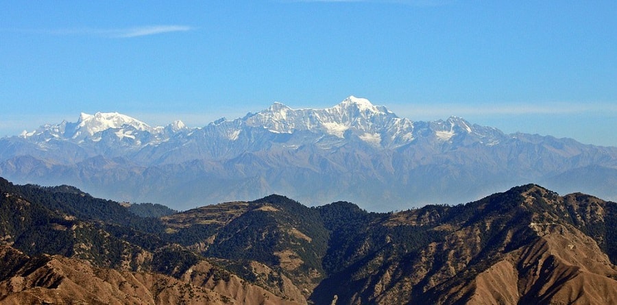
- Also known as Inner Himalayas, Central Himalayas or Himadri.
- Average elevation of 6,100 m and an average width of about 25 km.
- It is mainly formed of the central crystallines (granites and gneisses) overlain by metamorphosed sediments mainly limestone.
- Folds in this range are asymmetrical with steep south slope and gentle north slope giving hogback topography.
- Terminates at the syntaxial bends, one in the Nanga Parbat in north-west and the other in the Namcha Barwa in the north-east.
- This mountain range boasts of the tallest peaks of the world, most of which remain under perpetual snow.
- Regional name of Mount Everest
- Sagarmatha – Nepal
- Chomlungma – China (Tibet)
- Highest picks are
- Everest – 8848.86 m – Nepal
- K2 (Godwin Austen) – 8611 m – Karakoram range – PoK
- Kangchenjunga – 8586 – India
- Lhotse – 8516 m – Nepal
- Makalu – 8485 m – Nepal
- Mount Everest was first located by George Everest, Surveyor General of India in 1841
The Trans Himalayas
- Trans Himalayas ranges are immediately north of the Great Himalayan range.
- Also called the Tibetan Himalayas because most of it lies in Tibet.
- Zaskar, Ladakh, Kailas and Karakoram are the main ranges.
- It stretches for a distance of about 1,000 km in east-west direction.
- Average elevation is 3000 m above mean sea level.
- The average width of this region is 40 km at the extremities and about 225 km in the central part.
- Nanga Parbat (8126 m) is an important range which is in The Zaskar Range.
- Kailas Range (Gangdise in Chinese) in western Tibet is an offshoot of the Ladakh Range. The highest peak is Mount Kailas (6714 m). River Indus originates from the northern slopes of the Kailas range.
- Northern most range of the Trans-Himalaya in India is Karakoram Range also known as the Krishnagiri
- Karakoram Range extends eastwards from the Pamir for about 800 km.
- K2 (8,611 m)[Godwin Austen or Qogir] is the second highest peak in the world and the highest peak in the Indian Union.
- The Ladakh Plateau lies to the north-east of the Karakoram Range.
- It has been dissected into a number of plains and mountains [Soda Plains, Aksai Chin, Lingzi Tang, Depsang Plains and Chang Chenmo]

West to East Division of the Himalayas
- Western Himalayas
- Kashmir Himalayas
- Himachal Himalayas
- Kumaun Himalayas
- Central Himalayas
- Nepal Himalayas
- Darjeeling or Sikkim Himalayas
- Eastern Himalayas
- Bhutan Himalayas
- Arunachal Himalayas
- Purvanchal or Eastern Hills
Kashmir Himalayas
- Kashmir Himalaya are also famous for Karewa formations and those are famous for cultivation of saffron, apple, peach, almond etc.
- ‘Karewas’ in Kashmiri language refer to the lake deposits, found in the flat-topped terraces of the Kashmir valley and on the flanks of the Pir Panjal range.
- In Ladakh region Kashmir Himalayas is characterized by cold desert condition.
Himachal Himalayas
- It stretching over Himachal Pradesh.
- The beautiful and highly productive valleys of Kangra, Kullu, Manali, Lahul, and Spiti lie in Himachal Pradesh.
- These valleys are well known for orchards and scenic beauty.
- Shimla, Daihousie, Chamba, Dharaiushala, Kullu-Manali are the important hill stations of this region.
Kumaun Himalayas
- It lie between the Satluj and the Kali rivers.
- Its highest peak is Nanda Devi (7817 m).
- Other important peaks are Kamet (7756 m), Trisul (7140 m), Badrinath (7138), Kedarnath (6940 m) Dunagiri (7066 m), Gangotri (6615 m) are important.
- Gangotri, Milam, and Pindar are the main glaciers of Uttarakhand.
- Mussorrie, Nainital, Ranikhet, Almora, and Bageshwar are hill stations.
Central Himalayas
- It stretches from river Kali to river Tista for about 800 km.
- A major part of it lies in Nepal except the eastern part called Sikkim Himalayas and in the Darjeeling District of West Bengal.
- All the three ranges of the Himalayan mountains are represented here.
- The highest peaks of the world like Mt. Everest (8,850 m) Kangchenjunga (8,598 m), Makalu (8,181 m) are situated in this part of the Himalayan mountains.
- Lesser Himalaya is known as Mahabharat Lekh in this region.
>>>>>>

>>>>>>
Eastern Himalayas
- This part of the Himalayan mountains lies between the Tista river in the west and the Brahmaputra river in the east.
- It stretches for a distance of about 720 km.
- Also known as the Assam Himalayas, the Eastern Himalayas occupy mainly the areas of Arunachal Pradesh and Bhutan.
- Arunachal Himalayas show a marked dominance of fluvial erosion due to heavy rainfall.
Purvanchal or Eastern Hills
- Brahmaputra marks the eastern border of the Himalayan mountains.
- Beyond the Dihang gorge, the Himalayan mountains bend sharply towards south and form Purvanchal.
- They run along the India-Myanmar Border extending from Arunachal Pradesh in the north to Mizoram in the south.
- They are mostly composed of sandstones (Sedimentary rocks)
- Hills are covered with dense forest
- Purvanchal hills are convex to the west
- These hills are composed of
- Patkai Bum – Border between Arunachal Pradesh and Myanmar
- Naga Hills
- Manipuri Hills – Border between Manipur and Myanmar
- Lushai Hills
- Mizo Hills
- Extension of Purvanchal continues in Myanmar and Andaman & Nicobar Islands
Syntaxial Bends of the Himalayas
- The Himalayan mountains extend in the east-west direction from the Indus gorge in the west to the Brahmaputra gorge in the east.
- The Himalayan mountains ranges take sharp southward bends at these gorges.
- These bends are called syntaxial bends of the Himalayan mountains.
- The western syntaxial bend occurs near the Nanga Parbat where the Indus river has cut a deep gorge.
- The eastern syntaxial bend occurs near the Namche Barwa.
>>>>>>>

>>>>>>>
Importance of the Himalayan Mountains
Influence on Indian Climate
- They intercept the summer monsoons coming from the Bay of Bengal and Arabian Sea causing precipitation in the entire Ganga Plains, North-Eastern Hills.
- They direct the monsoon winds towards north-western India (Punjab, Haryana etc.
- But these regions receive most of the rainfall due to Western Disturbances coming from the Mediterranean regions.
- Protect northern-plains from the cold continental air masses of central Asia.
- The Himalayan mountains influence the path of Sub-tropical Jet stream flowing in the region.
- They split the jet stream and this split jet stream plays an important role in bring monsoons to India.
- If there was no Himalayas, the whole of India would have been a desert and its winters would have been very severe.
Defense
- The Himalayan mountains are a natural defense barrier.
- But the Chinese aggression on India in 1962 has reduced the defense significance of the Himalayan mountains.
Source of Rivers
- Rivers that feed nearly half a billion population of India originate in Himalayas.
Fertile Soil
- The swift flowing rivers from the Himalayan mountains bring enormous amount of silt (alluvium) which constantly enrich the Ganaga and Bramhaputra plains.
Hydroelectricity
- Due to its natural topography and swift flowing perennial rivers, the Himalayan mountains region offers several natural sites with great hydroelectric power generation potential.
- Many hydroelectric power plants have already been constructed.
- But all this comes at a great environmental costs.
Forest Wealth of the Himalayas
- The Himalayan mountains host rich coniferous and evergreen forests.
- Lower levels have tropical evergreen forests and higher levels have Alpine vegetation (Coniferous).
- The Himalayan mountains forests provide fuel wood and a large variety of timber for industries.
- The Himalayan mountains forests host wide variety riversof medicinal plants.
- Several patches are covered with grass offering rich pastures for grazing animals.
Agriculture
- Due to rugged and sloped terrain, the Himalayan mountains are not potential agricultural sites.
- Some slopes are terraced for cultivation. Rice is the main crop on the terraced slopes. The other crops are wheat, maize, potatoes, etc.
- Tea is a unique crop which can be grown only on the Shiwalik hill slopes in the region.
- Fruit cultivation is a major occupation. A wide variety of fruits such as apples, pears, grapes, mulberry, walnut, cherries, peaches, apricot, etc. are also grown in the Himalayan region.
Tourism
- The Himalayan mountains ranges have a large number of tourist spots.
- The hilly areas in the Himalayan mountains are not affected by hot winds like loo.
- Hence they offer cool and comfortable climate.
- The increasing popularity of winter sports has increased the rush of tourists in winters.
- Srinagar, Dalhousie, Dharamshala, Chamba, Shimla, Kulu, Manali, Mussoorie, Nainital, Ranikhet, Almora, Darjeeling, Mirik, Gangtok, etc. are important tourist centres in the Himalayan mountains.
Cultural Tourism
- The Himalayan mountains host many Hindu and Buddist shrines.
- Kailas, Amarnath, Badrinath, Kedarnath, Vaishnu Devi, Jwalaji, Uttarkashi, Gangotri, Yamunotri, etc. are important places of pilgrimage.
Mineral Resources in the Himalayas
- Geosynclinical deposits in tertiary rocks are regions of potential coal and oil reserves.
- Coal is found in Kashmir, Copper, lead, zinc, gold, silver, limestone, semi-precious and precious stones occur at some places in the Himalayan mountains.
- But the exploitation of these resources require advanced technologies which are not yet available.
- Also, disturbing such a fragile environment leads to more pain than gain (present hydroelectric power projects have already proved this).
Video Explanation
>>>>>>>


