Contents
>>>>>>
- Peninsular rivers of India are much older river than Himalayan rivers.
- They are discordant rivers
- Peninsular rivers are non-perennial rivers.
- Peninsular rivers have reached mature stage and their vertical down cutting is negligible.
- Rivers are characterized by broad and shallow valleys.
- Most of Peninsular rivers banks have gentle slopes.
- Western Ghats is the main water divider of peninsular rivers.
>>>>>>>>
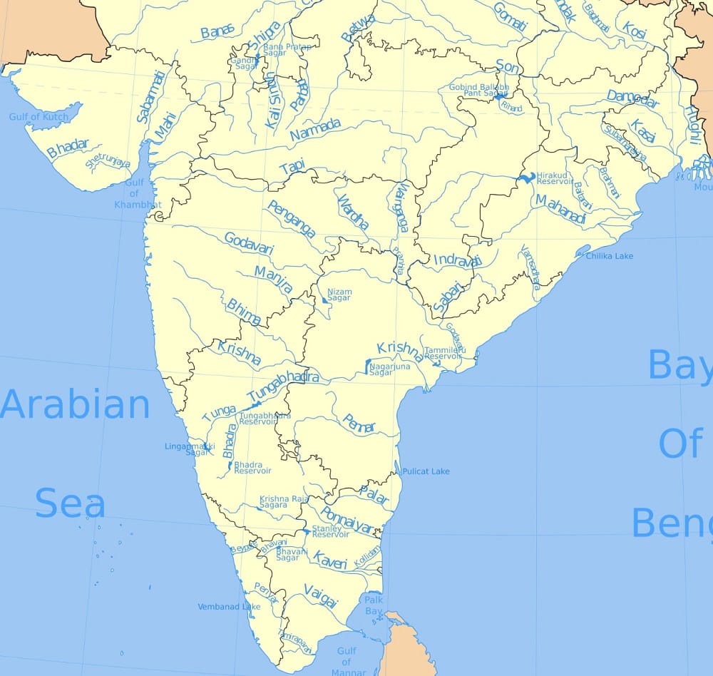
Peninsular River System
East Flowing Rivers
- Rivers that drain into Bay of Bengal
- These rivers from deltas at their mouths
- They carry larger amount of water than west flowing rivers
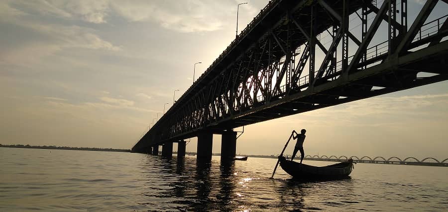
- The Mahanadi river, the Godavari river, the Krishna river, the Cauvery and several smaller rivers drains south-east into the Bay of Bengal.
>>>>>>>>
West Flowing Rivers
- Rivers that drain into Arabian Sea
- These rivers form estuaries at their mouths.
- They carry a lesser amount of water
- The Narmada river, the Tapi, the Mahi, Periyar river are flowing west
- As well as several small streams originating from the Western Ghats flow westwards into the Arabian Sea.
>>>>>>>>>>

>>>>>>>
Himalayan River System Peninsular River System Origin These rivets originate from the lofty Himalayan ranges These rivers originate in the Peninsular Catchment area These rivers have large basins and catchment areas These rivers have small basins and catchment areas Valleys Himalayan rivers flow through deep V – shaped valleys called gorges Peninsular rivers flow in comparatively shallow valleys . Drainage Type These are examples of antecedent drainage These are examples of consequent drainage Water Flow Himalayan rivers are perennial in nature Peninsular rivers receive water only from rainfall and water flows in these rivers in rainy season only Stage These rivers flow across the young fold mountains and are still in a youthful stage These rivers have been flowing in one of the oldest plateaus of the world and have reached maturity Meanders Rivers form meanders and often shift their beds. Rivers of the Peninsular Plateau follow more or less straight courses .
>>>>>>>>
>>>>>>>>
East Flowing Rivers – North to South
Subarnarekha River
- Source – Chota Nagpur plateau, Jharkhand
- Passes through – Jharkhand, West Bengal and Odisha.
- Left bank Tributaries – Dulang River
- Right bank Tributaries – Kanchi River, Kharkai River, Raru River, Garru River.
- Hundru Falls is created on the course of the Subarnarekha River.
- Jamshedpur is located at the confluence of Kharkai and Subarnarekha Rivers.
>>>>>>>>
>>>>>>>>
Budhabalanga River
- Source – Similipal hills, Odisha
- Passes through – Odisha
- Barehipani Falls, the 2nd highest waterfall in India, located in Simlipal National Park
>>>>>>>>
>>>>>>
Brahmani River
- Source – confluence of the Sankh and South Koel rivers near Rourkela
- Together with the Baitarani river, it forms a large delta before emptying into the Bay of Bengal at Dhamra
>>>>>>>>
>>>>>>>>
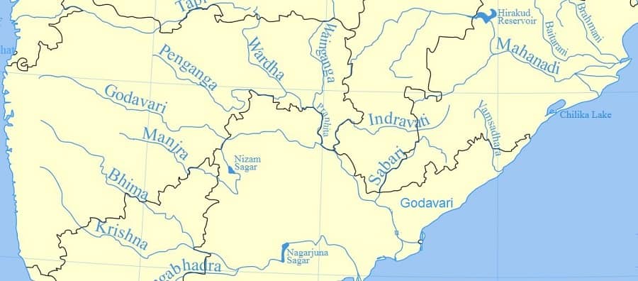
Mahanadi River
- Source – Dandakaranya, Raipur District, Chhattisgarh
- Length: 858 km
- Flows through – Chhattisgarh, Odisha
- Left bank Tributaries –Shivnath, Hasdeo, Mand and Ib
- Right bank Tributaries – Ong, Tel and Jonk
- Puri, at one of its mouths, is a famous pilgrimage site.
- Hirakud Dam constructed on it, at Sambalpur
- Important projects are the Mahanadi main canal and Tandula reservoir in Chhattisgarh
>>>>>>
>>>>>>>>
Rushikulya River
- Source – Daringbadi, Kandhamal, Odisha
- Mouth of the Rushikulya River is the largest mass nesting sites of olive ridley sea turtles in India
>>>>>>>>
>>>>>>>>
Gosthani River
- Source – Ananthagiri Hills of the Eastern Ghats, Andhra Pradesh
- Flows through the Borra Caves
>>>>>>>>
>>>>>>>
Vamsadhara River
- Source – Thuamul Rampur, Kalahandi district, Odisha
- Flows through – Odisha, Andhra Pradesh
- Mahendratanaya River is a major tributary of Vamsadhara
>>>>>>>>
>>>>>>>>
Nagavali River
- Source – Thuamul Rampur, Odisha
- Flows through – Odisha, Andhra Pradesh
>>>>>>>>>
>>>>>>>>
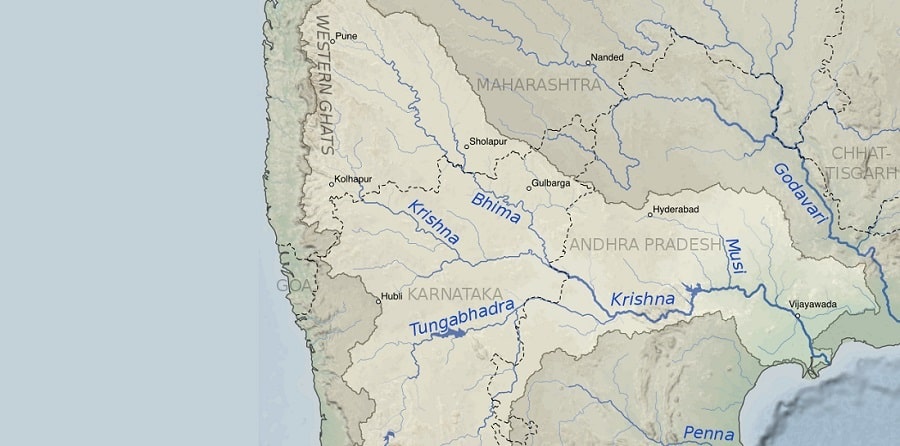
Godavari River
- Source – Brahmagiri Mountain (1,067 m), Tryambakeshwar, Nashik, Maharashtra
- Length – 1,465 km.
- Flows through – Maharashtra , Telangana, AP, Puducherry (Yanam)
- Godavari river is the largest river of the Peninsular rivers of India
- It is called as Dakshin Ganga.
- Left Bank Tributaries – Banganga, Kadva, Shivana, Purna, Kadam, Pranahita, Indravati, Taliperu, Sabari
- Right Bank Tributaries – Nasardi, Darna, Pravara, Sindphana, Manjira, Manair, Kinnerasani
- Below Rajahmundry, the Godavari river divides itself into two main streams
- Gautami Godavari on the east
- Vashishta Godavari on the west
>>>>>>>>
Tributaries of Godavari River
Pranhita River
- Source – Confluence of Wardha and Wainganga
- Flows through – Maharashtra , Telangana
- Pranhita river joins at Godavari River at Kaleswaram, Telangana
- It is the largest tributary of Godavari River
- Penganga River is an important tributaries of Wardha River
>>>>>>>>
Indravati River
- Source – Dandakaranya Range, Kalahandi, Odisha
- Flows through – Odisha, Chhattisgarh, Maharashtra
- Indravati river joins Godavari River at the junction of the boundaries of Maharashtra, Chhattisgarh and Telangana states.
>>>>>>>>
Manjira River
- Source – Balaghat range of hills, Maharashtra
- It is 724 km long, important right bank tributary.
- Manjira river joins the Godavari river after passing through the Nizam Sagar.
- It joins Godavari river at Nizamabad, Telangana.
>>>>>>>
>>>>>>>>
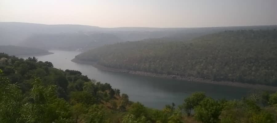
Krishna River
- Source – Mahabaleswar, Satara, MH
- Length – 1300 km
- Flows through – Maharashtra, Karnataka, Telangana and Andhra Pradesh
- Krishna river is the 2nd largest east flowing river of the Peninsular rivers of India.
- It is also 4th biggest river in terms of water inflows and river basin area in India
- Left Bank tributaries – Bhima, Dindi, Peddavagu, Musi, Paleru, Munneru
- Right bank tributaries – Venna, Koyna, Panchganga, Dudhaganga, Ghataprabha, Malaprabha, Tungabhadra
- Krishna river delta appears to merge with that formed by the Godavari river and extends about 35 km into the sea.
- Amaravati city, Guntur district new capital of Andhra Pradesh and Vijayawada city are located on the banks of the Krishna river.
>>>>>>>>
Tributaries of Krishna River
Koyna River
- Source – Mahableshwar, Satara, Maharashtra
- Koyna Dam was the main cause of a devastating earthquake (6.4 richter scale) in 1967 that killed 150 people.
- For electricity generating potential it is known as the Life Line of Maharashtra.
- Koyna river meets the Krishna river by Karad at Pritisangam.
>>>>>>>>
Tungabhadra River
- Source – confluence of Thunga and Bhadra rivers
- Flows through – Karnataka, Telangana, Andhra Pradesh
- Tungabhadra river joins Krishna river near Alampur, Mehaboobnagar, Telangana.
- In the epic Ramayana, Tungabhadra river was known as Pampa.
- Flood protection walls all along the rivers, constructed by Sri Krishna Devaraya.
>>>>>>>>
Bhima River
- Sour – Bhimashankarce, near pune
- Passes through – Maharashtra, Karnataka, and Telangana
- Bhima river passes through the town of Koregaon Bhima, Maharastra.
- It joins into the Krishna river along the border between Karnataka and Telangana near Raichur.
>>>>>>>>
Musi River
- Source – Anantagiri Hills, Vikarabad, Telangana
- Hyderabad stands on the banks of Musi river
- Himayat Sagar and Osman Sagar dams built on Musi river.
- Musi river joins the Krishna river at Vadapally in Nalgonda district, Telangana.
>>>>>>>>
>>>>>>>>
Penner River
- Source – Nandi Hills, Chikkaballapur district, Karnataka
- Passes through – Andhra Pradesh, Karnataka
- The only major project in the basin is the Somasila project
>>>>>>>>
>>>>>>
Palar River
- Source – Nandi Hills, Karnataka
- Passes through – Karnataka, Andhra Pradesh, Tamil Nadu
- It flows as an underground river for a long distance
>>>>>>>>
>>>>>>>>
Ponnaiyar River
- Source – Nandi Hills, Karnataka
- Passes through – Karnataka and Tamil Nadu
>>>>>>>
>>>>>>>>
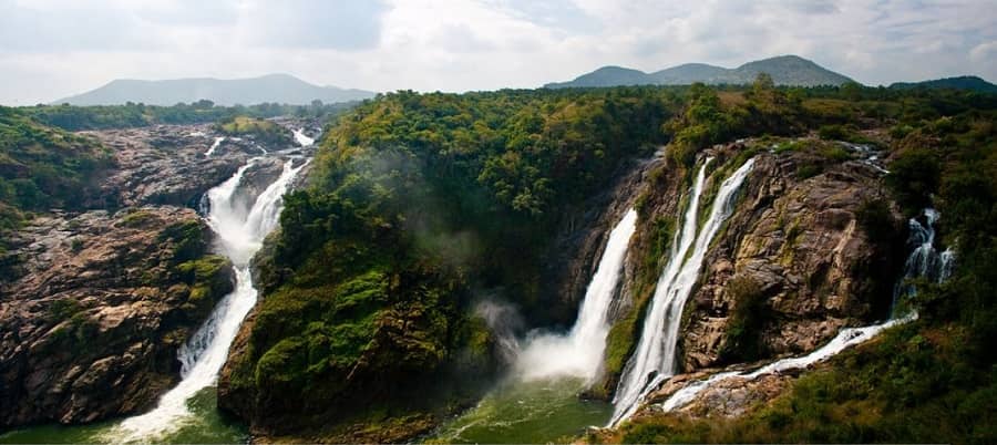
Kaveri (Cauvery) River
- Source – Talakaveri, Brahmagiri hills, Western Ghats, Karnataka
- Length – 800 km
- Passes through – Karnataka and Tamil Nadu
- Left Bank tributaries – Harangi, Hemavati, Shimsha, Arkavathy
- Right bank tributaries – Lakshmana Tirtha, Kabini, Bhavani, Noyyal, Amaravati, Moyar, Suvarnavati
- Kaveri river is called as Ganga of South.
- Sivasamudram waterfalls is created on the course of the Kaveri river.
- Krishnarajasagar in Karnataka, Mettur Dam in Tamil Nadu are important projects on Kaveri river.
- Srirangam Island is formed by the river Cauvery and the Kollidam, a tributary of the Kaveri river.
- Grand Anicut (Kallanai Dam) was constructed by a Chola king Karikalan in 1st Century, in Thanjavur District.
>>>>>>>>
Tributaries of Kaveri River
Amaravati River
- Source – Anamalai Hills, Kerala
- Passes through – Kerala, Tamil Nadu
>>>>>>>>
Bhavani River
- Source – Silent Valley National Park, Nilgiri hills, Kerala
- Passes through – Kerala, Tamil Nadu
>>>>>>>>
>>>>>>>>
Vaigai River
- Source – Varusanadu Hills, Tamil Nadu
- Passes through – Tamil Nadu
- Discharged in – Palk Strait
- Madurai situated on the bank of Vaigai river.
>>>>>>>>
>>>>>>>>
Thamirabarani River
- Source – Pothigai hills, Tamil Nadu
- Passes through – Tamil Nadu
- Discharged in – Gulf of Mannar
>>>>>>
>>>>>>>>
West Flowing Rivers – North to South
Ghaggar-Hakra River
- Source – Shivalik Hills, Himachal Pradesh
- Passes through – Thar Desert of Rajasthan
- Discharged in – Ottu, Haryana
- Its main tributaries are the Tangri, the Markanda, the Saraswati and the Chaitanya.
- It is an inland drainage river
- It is a seasonal river
- Most sites of the mature Harappan Civilisation are found along the bed of the Ghaggar-Hakkar river.
>>>>>>>>
>>>>>>>>
Luni (Salt River)
- Source – Pushkar Lake, Aravalli ranges, Rajasthan
- Passes through – Thar Desert of Rajasthan
- Length – 511 km
- Discharged in – Rann of Kachchh
- Luni river is an inland drainage.
>>>>>>>>
>>>>>>>>
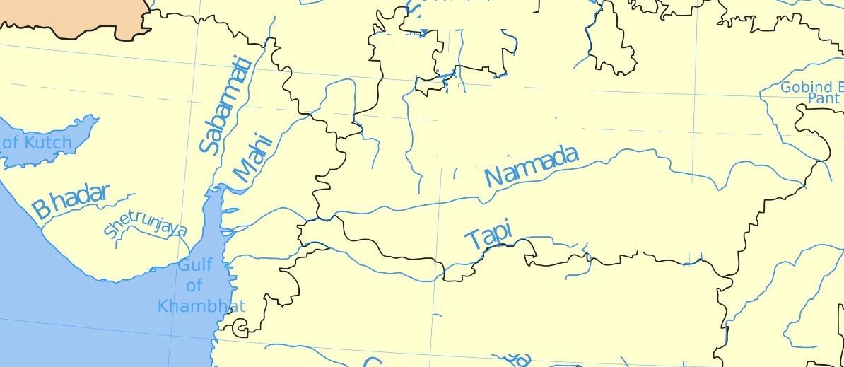
Sabarmati River
- Source – Dhebar lake, Aravalli ranges, Rajasthan
- Passes through – Rajasthan, Gujarat
- Discharged in – Gulf of Khambhat of Arabian Sea
- Left Bank tributaries – the Wakal, the Hathmati and the Vatrak.
- Right bank tributaries – the Sei
- Ahmedabad and Gandhinagar situated on the bank of Sabarmati river.
- Mahatma Gandhi established Sabarmati Ashram as his home on the banks of Sabarmati river.
- The Dharoi dam is located on the main river.
>>>>>>>>
>>>>>>>>
Mahi River
- Source – Vindhyas, Madhya pradesh,
- Passes through – Madhya Pradesh, Rajasthan and Gujarat
- Discharged in – Gulf of Khambhat of Arabian Sea
>>>>>>>
>>>>>>>>
Narmada River
- Source – Amarkantak Plateau, Madhya Pradesh
- Length – 1310km
- Passes through – Madhya Pradesh, Maharashtra, Gujarat
- Discharged in – Gulf of Khambhat of Arabian Sea
- Left Bank tributaries – Burhner, Banjar, Sher, Shakkar, Dudhi, Tawa, Ganjal, Chhota Tawa, Kundi, Goi
- Right bank tributaries – Hiran, Tendoni, Choral, Kolar, Man, Uri, Hatni, Orsang
- Narmada river is the largest west flowing river of the peninsular rivers of India
- It flows in a rift valley, between the Satpura and Vindhya ranges
- Dhuan Dhar Falls and Sahasradhara Falls created on the way of Narmada river.
- Narmada river created estuary before its mouth.
- There are several islands in the estuary of the Narmada river of which Aliabet is the largest.
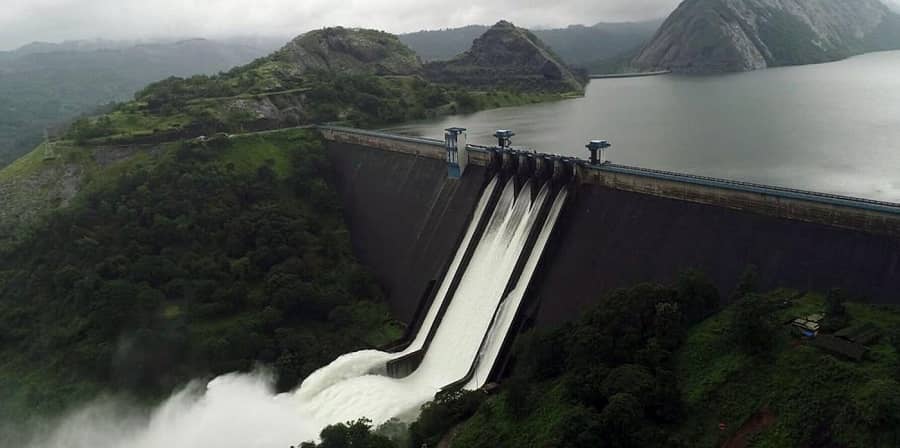
- The major Hydro Power Project in the basin of Narmada river are Indira Sagar, Sardar Sarovar, Omkareshwar, Bargi & Maheshwar.
>>>>>>>>
>>>>>>>>
Tapti River
- Source – Multai, Saptura range, Madhya Pradesh
- Passes through – Madhya Pradesh, Maharashtra, Gujarat
- Discharged in – Gulf of Khambhat of Arabian Sea
- Left Bank tributaries – Vaghur, Amravati, Buray, Panjhra, Bori, Girna, Purna, Mona and Sipna
- Right bank tributaries – Suki, Gomai, Arunavati and Aner
- Tapti river flows through a rift valley.
- Nepanagar and Surat situated on the bank of Tapti river.
- Hathnur Dam, Ukai Dam, Girna Dam are important project on Tapti river.
>>>>>>>>
>>>>>>>>
Mandovi River (Mhadei)
- Source – Bhimgad, Western Ghats, Karnataka
- Passes through – Karnataka ,Goa, Maharashtra
- Discharged in – Arabian Sea
- The river Mapusa is a tributary of the Mandovi river.
- Dudhsagar Falls and Varapoha Falls are located on this river
>>>>>>>>
>>>>>>>>
Kali River
- Source – Diggi, Karnataka
- Passes through – Karnataka
- Supa Dam constructed on it
>>>>>>>>
>>>>>>>>
Gangavali River
- Source – South of Dharwad, Western Ghats, Karnataka
- Passes through – Karnataka
- Magod Falls is created on the course of it
>>>>>>
>>>>>>>>
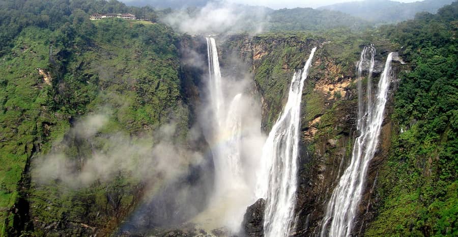
Sharavati River
- Source – Ambutheertha, Shimoga, Karnataka
- Passes through – Karnataka
- Jog Falls is created by the Sharavathi River
- Linganamakki dam, Gerusoppa dam constructed on it
>>>>>>>>
>>>>>>>>
Beypore / Chaliyar River
- Source – Elambaleri Hills, Wayanad Plateau of Kerala
- Passes through – Kerala
- Discharged in – Lakshadweep Sea
>>>>>>>>
>>>>>>>>
Bharathapuzha River
- Source – Anamalai Hills, Tamil Nadu
- Passes through – Tamil Nadu, Kerala
- 2nd longest river of Kerala
- Flows through Palghat gap
- Malampuzha dam is constructed on it
>>>>>>>
>>>>>>>>
Periyar River
- Source – Sivagiri Hills, Cardamom Hills, Idukki, Kerala
- Discharged in – Vembanad Lake
- Left Bank tributaries – Cheruthoni
- Right bank tributaries – Mullayar, Perinjankutti, Muthirapuzha, Edamala
- Periyar river is the longest river of Kerala.
- Mullaperiyar dam, Idukki dam are important project on Periyar river.
>>>>>>>>
>>>>>>>>
Pampa River
- Source – Pulachimalai hill, Western Ghats, Kerala
- Discharged in – Vembanad Lake
- 3rd longest river of Kerala
- Sabarimala temple dedicated to Lord Ayyappa is located on the banks of it.
- Pampa river is also known as Dakshina Bhageerathi
>>>>>>>>
>>>>>>>>
Evolution of the Peninsular Rivers of India
Theory – 1
- Geologists believe that the Sahyadri-Aravali axis was the main water divide in the past.
- As per this theory, existing peninsula is the remaining half of bigger landmass.
- Western Ghats were located in the middle of this landmass.
- Western part of the Peninsula cracked and submerged in the Arabian Sea
- Straight coastline, steep western slope of the Western Ghats, and the absence of delta formations on the western coast makes this theory a possibility.
>>>>>>
Theory – 2
- As per this theory, the west flowing peninsular rivers do not flow in the valleys formed by the rivers themselves.
- They have occupied two fault rifts in rocks running parallel to the Vindhyas.
- These faults are supposed to be caused by bend of the northern part of the Peninsula at the time of upheaval of the Himalayas.
- Peninsular block, south of the cracks, tilted slightly eastwards during the event thus giving the orientation to the entire drainage towards the Bay of Bengal.